The Castlegar area enjoys snow from November until March and so nordic skiing is one of the most popular winter activities here. Whether you prefer fast skate skiing for fitness, or slower relaxed cross-country through untouched snow to see the sites, there is something for every nordic skier living in, or visiting, Castlegar. And the best part is there are innumerable free areas to explore from wooded glades and lake-side trails to downtown parks, and decommissioned logging roads that lead you into the beautiful alpine.
If perfectly groomed trails are more your style, you can find them at the nearest alpine resorts but the most commonly accessed ones are near the city, towards Paulson Summit, and maintained by the Castlegar Nordic Ski Club. There you’ll find almost 50-kilometres worth of them that can be accessed with a membership or via a small day fee. For more info about these trails as well as other areas in which to nordic ski in Castlegar, read on.
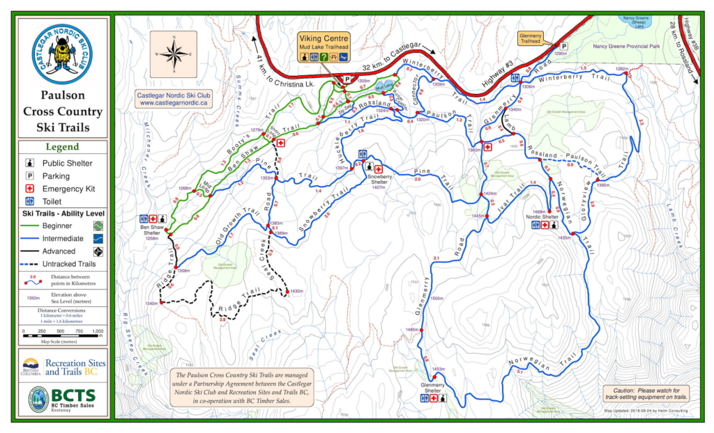
Paulson Cross-Country Ski Trails
Maintained by the Castlegar Nordic Ski Club, this area offers 53 kilometres of interconnected trails, 45 of which are groomed and maintained. They include easy, moderate and more challenging trails that boast multiple shelters and warming huts. Some trails skirt Nancy Greene Provincial Park while others take you past old growth management areas, alpine ridge lines and frozen lakes. The wider, groomed trails are suitable for skate skiing and, because the area is located at an elevation of 1,300 metres, it offers the longest season for nordic skiers in the region.
Access: There are two trailheads for the Paulson ski area but the most popular is at Mud Lake, where you’ll also find the Viking Centre. From Castlegar, drive 32 kilometres on Highway 3 towards the Paulson Summit. You’ll see the parking lot and Viking Centre is on your left.
Information: To fund the maintenance of these trails, the Castlegar Nordic Ski Club sells annual memberships or there is a small day use fee. Visit the Castlegar Nordic Ski Club website for more info.
The C&W Railway Trail
The Columbia and Western Railway Trail is a converted rail line that runs from Castlegar to Christina Lake and is part of the Trans-Canada Trail. It is free to use but not groomed in the winter months so it’s more suitable for classic cross-country skiers. People typically access it south of Hugh Keenleyside Dam at the terminus of Arrow Lakes Drive. From here you’ll gradually climb and enjoy excellent views of Lower Arrow Lakes. There is a lot of history on this particular trail – in fact, when it was an operating railway, it was the site of assassination: an explosion on the train killed Doukhobor leader Peter Verigin.
Access: From downtown, follow Columbia Drive north to Arrow Lakes Drive and take this to its terminus near the Hugh Keenleyside Dam.
Information: Visit the C&W Railway Trail section of the Trails BC website.
Castlegar Golf Club
The Castlegar Golf Club is an 18-hole course that offers a lot of space to roam in the winter time, especially on cross-country skis. The grounds enjoy plenty of sunshine in the winter and, because it’s situated on the shores of the Columbia River, there’s a lot to see. The best part is it’s free to access in the winter and it’s an easy 10-minute drive from downtown. There aren’t any groomed trails here but there’s a lot of flat space making in an excellent spot for an afternoon outing with the family or to take those who might be new to cross-country skiing.
Access: The golf course is located on Aaron Road, which is just north of the West Kootenay Regional Airport off of Highway 3.
Information: Although not open in the winter months, you can still see what the grounds look like and learn more about the golf course at golfcastlegar.com.
Slocan Valley Rail Trail
Another popular trail that’s free to use is the Slocan Valley Rail Trail, which winds its way from Slocan Lake towards the Kootenay River for 52 kilometres. There are seven trailheads but the closest to Castlegar is at Crescent Valley, about 30-kilometres north of the city. This non-motorized trail is maintained by volunteers and gets groomed occasionally. It offers beautiful views of the surrounding mountain ranges, including the Valhallas and Frog Peak in the Bonningtons, as it winds its way alongside the Slocan River.
Access: From Castlegar follow Highway 3a north for about 30 kilometres and turn west at the junction onto Highway 6. Crescent Valley is the first community you come to after a kilometre.
Information: Visit the Slocan Valley Rail Trail website for more information, maps and how to become a member of donate to help volunteer efforts.