There’s something awe-inspiring about walking through an old growth forest. To be amongst trees that were around before settlers arrived in Canada is a humbling thing. And to be surrounded by living beings that are so large, yet so silent, is enchanting. Today, there are multiple pockets of old growth forests in the West Kootenay region that are made up of cedar, hemlock, pine, fir, and spruce, and most are protected by the province. Some can only be accessed by boat, such as the stand at Nemo Creek on the west side of Slocan Lake, and others require multiple-day journeys to get to, such as the Earl Grey Pass Trail.
However, there are several easily accessible hiking trails within an easy drive of Castlegar that take you through old growth forests. The West Kootenay EcoSociety published a brochure detailing each one and you can find it on their website. The organization explains that the region is an inland temperate rainforest and the old growth stands that still exist are important because they’re home to species at risk such as wolverine, mountain caribou, western screech owls, and pileated woodpeckers. They also store large amounts of carbon and nutrients, which helps mitigate climate change.
Beyond that, they’re simply beautiful places to visit are perfect family destinations when the weather is warm. Here are our picks for the best old growth hikes near Castlegar.
Murphy Creek (aka 100 Acre Wood)
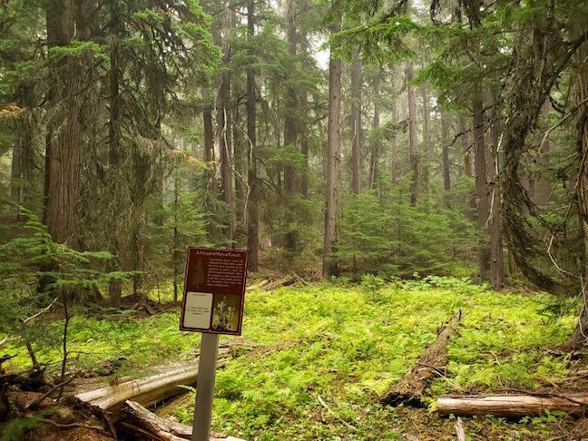
The Murphy Creek Trail in Rossland is also known as the 100 Acre Wood and it’s an easy 1.5-kilometre-long loop through a magnificent forest that includes old growth cedar, larch, and white pine. It also features informational signage that explain the area’s history, evolution, and importance.
Directions: From Castlegar drive Hwy 3 West for about 26 kilometres and then turn south onto Hwy 3B. Drive this for about 12 kilometres and you’ll see a large sign on your left for the 100 Acre Forest. Drive down this road until you reach the fork 100 metres ahead, take a right, and then continue another 250 metres until you reach the parking lot and trailhead.
Merry Creek Trails

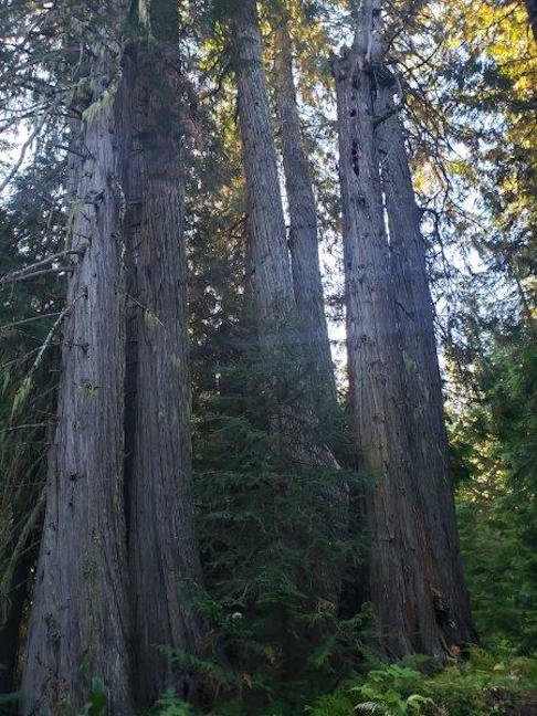
Merry Creek is the closest area to Castlegar that features old growth trees. Although there aren’t large stands of old growth here, there are beautiful, large cedar trees that can be found alongside the trails. Merry Creek is a well-known mountain bike destination with offerings that range from easy to expert but there’s also a popular hiking trail called the Merry Creek Trail that follows the stretch of forest between the road and the rushing waters of the creek. The 3.6-kilometre loop trail is relatively easy with only 120 metres of elevation gain, and you’ll see some impressive trees while on it, the largest being a giant cedar at the northernmost part of the hike.
Directions: Follow Highway 3 west from Castlegar and at the top of the first rise out of the city, keep an eye out for the Merry Creek Forest Service Road on your right. Take this and drive about two kilometres to the parking area. The Merry Creek hiking loop begin here.
Char Creek (aka Ka Papa Cedars Trail)
The Char Creek Interpretive Forest, also known as the Ka Papa Cedars Trail, is located east of Salmo on Highway 3, near the Kootenay Pass. It’s an easy two-kilometre loop trail that winds its way through a lush forest floor and past huge, ancient cedars. It’s a great place to stop and stretch your legs if travelling the Kootenay Pass.
Directions: From Castlegar head east on Hwy 3 past Salmo and towards Creston for 86 kilometres. You will see a large pullout to your left with Ka Papa Cedar Trail signs high in the trees. Here’s the Google map.
Ymir Trails
The old growth portion of Ymir’s scenic trail makes up one kilometre of the eight-kilometre loop and includes some impressively large cedar trees as well as huge stumps and evidence where past loggers fell the giants using hand saws. The rest of the loop follows the Salmo River via the Great Northern Rail Trail and winds its way past a waterfall, swimming hole complete with diving board, and an ancient cemetery.
Directions: From Castlegar head east on Hwy 3 and turn north on Hwy 6. Drive through Salmo and 13 kilometres later turn right onto 1st Avenue and follow this into Ymir. Park on the main strip and follow the signs to the trails. Here’s the Google map.
Kokanee Old Growth Trail
Kokanee Creek Provincial Park is an amazing day-trip destination for a variety of reasons as it has a Kokanee salmon interpretation centre, multiple beaches and playgrounds, and excellent mountain biking trails. There’s also an old growth hike which is located 11 kilometres north of the main park and it features an easy to moderate interpretive trail through an old cedar and hemlock forest. Aside from huge stands of trees you’ll also see historic remains of the mining and logging that happened in the area a century ago.
Directions: Travel east on Hwy 3A past Nelson to the Gibson Lake/Kokanee Glacier Provincial Park access road. Drive the gravel access road (high clearance isn’t required) for 11.4 kilometres to the trailhead sign. Parking for six vehicles is located about 50 meters past the trailhead sign. Here is the Google map.